
Your Land – Our Expertise
At Vaquero Land Services, we combine cutting-edge drone technology with local expertise to provide accurate wildlife and land assessments across thousands of acres in Texas. We’re transforming how landowners manage game, qualify for tax incentives, and make informed land decisions.
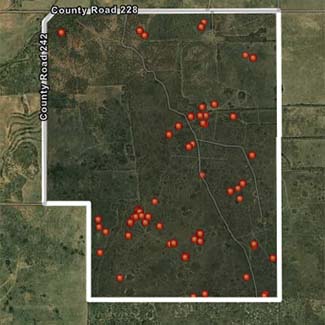
Vaquero offers aerial wildlife surveys, geotagged photos, game mapping, pest control, and population counts-supporting MLDP, 1-D-1 tax benefits, land management, marketing, and expert guidance for buying or selling rural properties.
Aerial
Surveying

Geotagged
Photos
Game
Maps

Your Land – Our Expertise
At Vaquero Land Services, we combine cutting-edge drone technology with local expertise to provide accurate wildlife and land assessments across thousands of acres in Texas. We’re transforming how landowners manage game, qualify for tax incentives, and make informed land decisions.
Aerial Surveying
Drone aerial surveying uses UAVs with cameras/sensors for efficient, high-resolution landscape mapping and analysis.
Geotagged Photos
Geotagged photos are images embedded with GPS coordinates, enabling precise location tracking and mapping.
Game Maps
Game mapping involves the use of GPS data to track and visualize wildlife movements for ongoing analysis and management.